A Ridge too far – Mick track
14/3/2026
Having always had an interest in aviation, the sites of aircraft accidents with extant debris has always been a draw, and in particular the site of the RNZAF Ventura crash inland from Ōtaki has been on my to do list.
While researching the trip to this site, I realised that it might also be possible, in a weekend, to travel to the Island Forks biodiversity hut at the same time, and so a trip to the western side of the Tararua was concieved.
Just two of us set off for Ōtaki on Saturday morning, with plans to be on the track for 10am, and giving us a around 9 hours for the first day. Leaving Greytown at 7am we were in Ōtaki just after 9am so we had a chance to stop at “Blackhood Bakes” for coffee and one of their fantastic pastries, before heading to the start point.
Unfortunately, despite having read previous trip reports of the Mick track, the first obstacle was that arriving at Waitohu quarry, we were met with some definate instruction not to travel across the property, in the form of several new signs at the entrance. Following a look at access maps on the “Herenga ā Nuku Aotearoa” website, and being no wiser to access to the track, we called the quarry for information. We were told access was definatly not across the quarry property and was across the adjoining farm with access off Waitohu road (GR 853849 BN33).
Once we found the entrance point we were quickly into our wet weather gear, as there was still some drizzle about, and onto the farm property which had bright blue poles to guide us to the start of the track. The farm was easy walking, but at times we found it difficult to maintain the expected route. We had decided while crossing the farm to head up the old forestry tracks toward Tangata Maunga then across to Mick, saving the steeper track for the descent the following day.
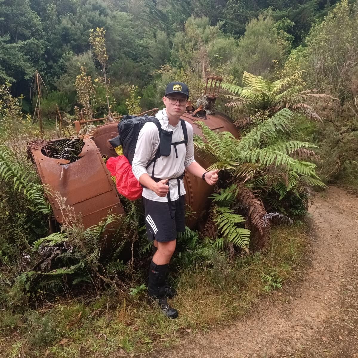
The Forestry track was well benched, wide, and a gentle climb, with horses shoe prints testiment to nature of the travel. At 11.30am we stopped close to Ringawhati/ .408, for a quick drink and to reduce layers as the weather was cool but dry by this stage. The forecast was for improving weather over the weekend, which we looked forward to. Another 30 minutes and we arrived at .533, finding the remains of a steam boiler and a large goat with a huge pair of horns, this was turn around point on the logging track. The track remained easy to follow and the gradient was still easy past .633 to the obvious track down to Waitohu lodge. It was warmer outside the building than in, and so with a good view down the Ōtaki
valley and Kapīti island, we enjoyed an “Al fresco” lunch.
Post lunch, we walked along the last of the logging track to the point where it swung from a SE to a SW direction and we were delighted to find that the spur up to Tangata Maunga had a good footpad along it up to the open top. We were however, less happy to find that the open top on the map is in fact composed of leatherwood and new growth! We found a small footpad that had less fight than the surrounding vegetation, and made our way to the weather station, not for any other reason, except, because its there! It was 2pm and by now it had warmed considerably, with the sun breaking through the cloud.
Unfortunately, on leaving we were momentarily disorientated, and left in the southerly, rather than northly direction, finally making it “through” the Leatherwood back to the weather station via .912 -a 45 minute detour! We did however get the opportunity to fill our now empty water bottles from a small tarn, using Finlay’s chlorine tabs to disinfect the slightly murky water.
Travelling back towards .874 along the ridge top, we found it was easier to drop off the top of the ridge and traverse across into the more open wooded section. We then moved back up on to the ridge top and started to pick up occasional footpad and purple blaze markers, that appeared to have been recently hung. The ridge was easily followed, however there was a lot of windfall and progress was slower than we might have liked.
It took until 4pm to get to Mick, approximately 1.5 hours to cover 1.6 kms. The summit of Mick is non descript, remains in the bushline and has no views, with the remnants of a walking pole the apparent marker of this named high point!
Following the discombobulated departure from Tangata Maunga, we stopped to check our direction of travel carefully to start towards the SE ridge and .975. We were by now concerned about reaching Island Forks by dark, knowing that we would have a river crossing before the hut.
We started down the spur towards the saddle from the high point, only to find that the terrain worsened as we descended, becoming quite steep, and very dense. In addition due to the heavy rain on the previous day it was also dangerously slippy. After nearly 20 minutes we had not covered the 300m to the saddle and we realised that we would unlikely make the hut in reasonable time. We considered making our way part way down and camping, but needed a water source for the night, and would need to retrace the route back the following day, whether we managed to get to Island Forks or not. Therefore we decided to retrace our route back up to Mick.
The new plan was to head down the Mick track, with a plan to find some water, then somewhere to camp for the night, after looking at the plane wreck on the way. We attempted to find some water at the top of the creek below .860 , but there was nothing in the upper part of the stream, so carried on along the track to near to .698, where we saw some parts of the aircraft wreckage on the track.
Following a quick search on the southern side of the track, and having found no other wreckage, we had a quick look to the north of the track, again finding no other wreckage (particularly the famous wing!). It was now 6pm, so we carried on down the track 20m and looked again over the southern side, with no sign of further aircraft parts. We decided to head back up past the original search area and have a last look. Fortunately Finlay finally saw the wing in the bush and we were able to have a look at the remains that exist around this spot. We spent about 20 minutes having a look, before departing, pausing for a moment to remember the four airmen that lost their lives in the accident.
Heading down the track, it remained steep with a lot of thick new growth across the terrain, and we couldn’t find a good camp spot. We also remained short of water, and decided to make the Waitohu stream our goal. We passed the “Permolat plane” marker at the bottom of the descent at 7.15pm, and came out onto the river flats a few minutes later. We took the opportunity to have a good drink and to fill bottles with water not tainted with a chlorine taste!
We travelled a little way down the side of the stream, and realised how marshy the ground was, not particulary appealing for camping on. From this point it was to be relatively flat and only about 4 km to the road end, so we started to think, that we might just head back to the car, and travel home, having completed a full days tramp.
Unfortunately, there appeared to be no track markers along the Waitohu valley, and we started to encounter a lot of gorse and thick undergrowth, necessitating some bush bashing, and eventually we were forced to travel down one of the side streams into the Waitohu stream itself, to enable us to proceed. It was dark by now, so we were travelling on headlamps. We finally decided it was quicker to travel in the stream, than to try to follow the track, with only about 2 kms of travel to the farm boundary. The water level was low, generally only up to knee height, although Finlay did manage to slip, and was up to waist height while sitting! We were lucky enough to spot quite a few eels, and some trout in the stream, and glow worms on the sides of the bank.
We climbed out onto the four wheel drive track a little before reaching the farm tracks, and made fast progress along the route we had taken in the morning, back to the car, arriving at 10pm, almost 12 hours after leaving!
We had a quick dinner, before departing, and heading back to the Wairarapa to end a very long day trip, 19 hours door to door.
Party – Finlay, Conrad (leader and scribe)
Postscript – on the farm track coming back to the car, we discussed Failure Vs Success on a trip. Was the day a failure? We hadn’t reached the intended destination or spent the weekend out as intended. We had visited one of the unofficial huts, and the Ventura crash site. We had had a 12 hour adventure, visiting an area neither of us had been to before. We had been smart enough to change plans and not to “carry on regardless”, and had both arrived back safe and well. We decided that the trip was a definatley not a failure, but that it had perhaps been a ridge too far...